The Earth as a Canvas: The Great Sculptors of Nature #
Imagine our planet not as a finished statue, but as a piece of clay that is constantly being molded. Two great forces are at work here. The Endogenic Forces (from within) work tirelessly to build mountains and lift continents, creating irregularities. But the moment these features rise, the Exogenic Forces (from the atmosphere) declare war. Their goal is Gradation—to wear down the high mountains (degradation) and fill up the low valleys (aggradation), ultimately trying to flatten the Earth into a featureless surface called a Peneplain.
Let us meet the five master sculptors who shape our world: Running Water, Groundwater, Glaciers, Wind, and Waves.
Part 1: Fluvial Landforms – The Master Carver, Running Water #
The Story of the River: The river is the most powerful sculptor in humid regions. Its life resembles that of a human—impulsive youth, steady maturity, and tired old age.
1. The Youth (Mountain Stage): Born from glaciers or springs, the river rushes down steep slopes. It is aggressive. It doesn’t look left or right; it cuts straight down (vertical erosion).
- V-Shaped Valleys & Gorges: The river carves deep, narrow valleys. When the sides are very steep and rocky, it forms a Gorge (e.g., the Indus Gorge in the Himalayas). If the rocks are layered horizontally, it carves step-like sides to form a Canyon (e.g., Grand Canyon, USA).
- Waterfalls: When the river encounters a layer of hard rock over soft rock, the soft rock erodes faster, creating a ledge over which the water plummets. Famous examples include Jog Falls (Karnataka) and Kunchikal Falls (highest in India).
- Plunge Pools: At the foot of the waterfall, the swirling water drills deep holes into the rockbed called plunge pools.
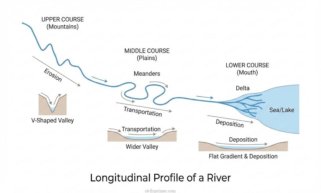
2. Maturity (Plain Stage): As the river enters the plains, it slows down. It stops cutting deep and starts cutting sideways (lateral erosion), widening its Valley.
- Meanders: The river begins to twist and turn like a snake. These loops are called Meanders.
- Oxbow Lakes: Sometimes, the river curves so much that the loop gets cut off from the main channel, leaving behind a crescent-shaped lake called an Oxbow Lake. These are common in the Ganga-Brahmaputra plains.
3. Old Age (Delta Stage): Approaching the sea, the river is exhausted and choked with sediment. It splits into many channels (distributaries).
- Deltas: The sediment piles up at the mouth, creating a triangular landform. The Sunderbans (Ganga-Brahmaputra) is the world’s largest delta.
- Arcuate Delta: Fan-shaped (e.g., Nile, Ganga).
- Bird’s Foot Delta: Resembles a bird’s claw (e.g., Mississippi).
Economic Utility
Agriculture: Floodplains and Deltas (like the Indo-Gangetic plain) provide the most fertile alluvial soil, serving as the “granaries of the world”.
Civilization: Rivers provide water for irrigation and navigation, historically supporting dense populations.
Act 2: Karst Landforms –The Phantom Architect – Groundwater #
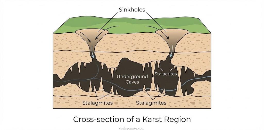
The Story of the Hidden Rivers: In regions made of Limestone or Dolomite, the sculptor works in the dark. Rainwater mixes with carbon dioxide to form weak Carbonic Acid, which dissolves the rocks. This creates a magical landscape called Karst Topography.
1. The Surface Dissolves (Erosional):
- Sinkholes: The ground is dotted with funnel-shaped holes where the roof of underground caverns has collapsed.
- Lapies: The surface rock becomes jagged with sharp ridges and grooves due to uneven solution activity.
2. The Underground Palaces (Depositional): Water drips into underground Caves, carrying dissolved calcium. As it drips, the water evaporates, leaving the stone behind.
- Stalactites: Icicle-like stone pillars hanging down from the cave roof.
- Stalagmites: Stone mounds growing up from the cave floor.
- Pillars: When the two meet, they form a solid column.
Examples: Borra Caves (Andhra Pradesh), Gupt Godavari (Chitrakoot), and Limestone Caves in Meghalaya.
Economic Utility
Tourism: Caves attract tourists (e.g., Mammoth Cave, USA).
Resources: Limestone is a key raw material for the cement industry.
Act 3: The Moving Mountains – Glaciers #
The Story of Ice: A glacier is a river of ice. It moves slowly but with tremendous weight, acting like a giant bulldozer or sandpaper, scouring the earth.
1. The High Mountains (Erosional):
- U-Shaped Valleys: Unlike rivers (V-shape), glaciers widen the Valley floor, creating a U-shape.
- Cirque: The glacier carves a deep, armchair-shaped hollow on the mountainside. When the ice melts, it forms a Tarn Lake.
- Horns: When cirques erode a mountain from three sides, a sharp, pyramid-like peak is left, called a Horn (e.g., Matterhorn in Alps).
- Hanging Valleys: Tributary glaciers cut shallower valleys than the main glacier. When the ice melts, these tributary valleys are left “hanging” high above the main Valley floor, often creating waterfalls.
2. The Dumping Ground (Depositional): The debris carried by a glacier is called Till or Moraines.
- Drumlins: The glacier deposits Till in the shape of inverted boats or spoons. These indicate the direction of ice flow.
- Eskers: Long, winding ridges of sand and gravel deposited by streams flowing under the ice.
- Examples: Siachen and Gangotri glaciers in the Himalayas.
Economic Utility
Tourism: Glacial landscapes like Switzerland and Kashmir are prime tourist destinations.
Water Source: Glaciers are the freshwater reservoirs feeding perennial rivers (Ganga, Yamuna) essential for agriculture.
Engineering: Eskers are often used as ready-made embankments for roads and railways.

Act 4: The Desert Artist – Wind (Aeolian Landforms) #
The Story of the Dry Lands: In hot deserts, wind is the master. It lifts loose particles (Deflation) and uses sand grains to scrub rocks (Abrasion).
1. The Sculptures (Erosional):
- Mushroom Rocks: Wind erodes the bottom of a rock faster than the top (because sand is heavy and stays close to the ground), creating rocks that look like mushrooms.
- Yardangs & Zeugen: Wind carves soft rocks into long, grooved ridges.
- Inselbergs: Isolated, rounded hills of resistant rock rising abruptly from the plain.
2. The Sea of Sand (Depositional):
- Sand Dunes:
- Barchans: Crescent-shaped dunes with tips pointing downwind.
- Seif (Linear): Long, sword-like ridges of sand parallel to the wind direction.
- Loess: Fine dust blown far beyond the desert. Extensive Loess deposits in China and the Pampas of Argentina create very fertile soil.
Examples: The Thar Desert in India.

Economic Utility
Agriculture: Loess plains are highly fertile for crops (e.g., Wheat in China/USA).
Oasis: Depressions carved by wind (deflation hollows) can reach the water table, creating Oases that support life and agriculture (e.g., Date Palms).
Act 5: The Relentless Pounder – Waves (Marine Landforms) #
The Story of the Coast: The sea never sleeps. Waves act like hammers, eroding the land, and like conveyor belts, depositing sand.
1. The Attack (Erosional):
- Cliffs: High, steep rock faces formed by wave impact.
- Caves, Arches, and Stacks: Waves hollow out weak rocks to form Caves. If they cut through a headland, an Arch forms. When the roof collapses, a lonely pillar called a Stack remains.

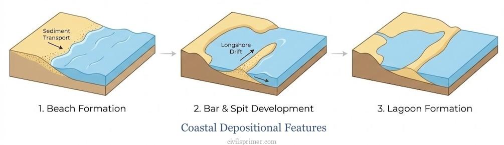
2. The Build-Up (Depositional):
- Beaches: Sands and pebbles deposited along the shore.
- Bars and Spits: Ridges of sand blocking a bay. A Spit is attached to land at one end; a Bar closes off the bay completely.
- Lagoons: A lake of seawater trapped behind a bar. Chilika Lake (Odisha) and Pulicat Lake are famous examples.
Economic Utility:
Ports & Harbours: Indented coastlines (Fjords/Rias) provide natural harbors for trade (e.g., Rotterdam).
Resources: Beaches contain mineral sands (e.g., Monazite/Thorium in Kerala).
Tourism: Coastal features like beaches and Coral atolls (Lakshadweep) are major tourist hubs.
UPSC Mains Subjective Previous Years Questions #
- 2020 → How will the melting of Himalayan glaciers have a far-reaching impact on the water resources of India?
- 2013 → There is no formation of deltas by rivers of the Western Ghat. Why?
Answer Writing Minors #
Introduction: “The Earth’s surface is a dynamic interface continuously sculpted by geomorphic agents such as running water, groundwater, glaciers, wind, and waves. These Exogenic Forces act upon the Lithosphere through processes of erosion, transportation, and deposition, striving towards gradation and shaping diverse landforms that determine the region’s economic potential and habitability.”
Conclusion: “Conclusively, the evolution of landforms is a result of the complex interplay between climatic agents of Denudation and the geological structure of the region. Understanding these geomorphological processes is essential not only for geography but also for sustainable economic planning in agriculture, mining, and disaster management.”
Related Latest Current Affairs #
- October, 2025: Erra Matti Dibbalu (Red Sand Dunes) included in UNESCO Tentative List The Erra Matti Dibbalu near Visakhapatnam, Andhra Pradesh, were nominated for UNESCO recognition. These rare aeolian and marine depositional landforms (red Sand Dunes) formed during the late Quaternary Age (~2.6 million years ago) and serve as a natural archive of paleo-climatic and sea-level changes,.
- September, 2025: Discovery of Cave-Dwelling Fish in Mawjymbuin Cave Researchers discovered a new fish species in the Mawjymbuin Cave in Meghalaya. The cave is a distinct Karst landform made of calcareous Sandstone, featuring numerous Stalagmites formed by calcium carbonate deposition and underground (hypogean) environments,.
- August, 2025: Morphological Changes in Bhagirathi River A flash flood in the Fluvial system of the Himalayas significantly altered the course and morphology of the Bhagirathi River in Uttarakhand. The event forced a tributary (Kheer Gad) back to its old channel, demonstrating the dynamic nature of river channels in tectonically active zones.
- August, 2025: Retreat of the Gangotri Glacier A new study revealed that the Gangotri Glacier (source of the Ganga) has lost nearly 10% of its snowmelt flow volume over four decades. The glacier is thinning and its snout is retreating, altering the glacial landform and affecting downstream hydrological regimes due to climate change,.
- July, 2025: Coastal Erosion Crisis in Chile Research indicated that severe coastal erosion is causing beaches in Chile to vanish. Driven by climate-induced stronger swells and rising sea levels, this wave/marine erosion process is reshaping the coastline and degrading dune systems.
- July, 2025: Glacial Melt on Mount Cilo (Turkey) The glaciers of Mount Cilo, Turkey’s second-highest peak, have lost 50% of their ice cover in 40 years. This rapid glacial retreat is reshaping the glaciated valleys and altering the water cycle in the East Taurus Mountain range,.
- June, 2025: Degradation of Chambal River Ravines Illegal sand mining is threatening the Chambal River, known for its unique Ravine (badland) topography. These erosional landforms, created by the fluvial action of the river in semi-arid conditions, are being destabilized by human activity,.
- January, 2025: Understanding Artesian Conditions Articles explained Artesian conditions, a specific groundwater phenomenon where water is confined between impermeable rock layers under pressure. This geological setup allows water to flow naturally to the surface without pumping, as seen in the Great Artesian Basin of Australia.
- December, 2024: Salar de Uyuni Salt Flats The Salar de Uyuni in Bolivia, the world’s largest salt flat, was highlighted for its lithium reserves. This depositional landform originated from prehistoric lakes that evaporated, leaving behind vast expanses of salt and minerals (evaporites).