Topics Covered:
Ocean Relief: Continental shelf, slope, abyssal plains, and mid-oceanic ridges
Imagine you are not just studying for an exam, but embarking on an expedition. We are leaving the familiar lands of the continents to explore the 71% of our planet that lies beneath the blue waters. The ocean floor is not a flat, boring bowl; it is a rugged landscape filled with the world’s longest mountain ranges, deepest trenches, and vastest plains. To understand this, we must dive deep.
Part 1: The Continental Shelf #
Our journey begins at the coast. As you walk into the waves, the ground beneath your feet slopes gently. You are still standing on the continent, even though you are underwater. This submerged edge of the continent is known as the Continental Shelf. It is the transition zone between the land we live on and the deep ocean basins.
1. Definition & Extent: Think of the Continental Shelf as the extended margin of each continent. It is occupied by relatively shallow seas and gulfs. It is the shallowest part of the ocean, showing an average gradient of merely 1° or even less. The shelf typically ends at a precipice—a very steep slope called the shelf break. While the average width of these shelves is about 80 km, nature loves variety.
- Narrow Shelves: If you were standing on the coast of Chile or the west coast of Sumatra, the shelf would be almost absent or very narrow. This occurs often along convergent plate boundaries.
- Wide Shelves: Conversely, if you traveled to the Arctic Ocean, the Siberian shelf stretches out to a massive 1,500 km in width, making it the largest in the world,. In India, the shelves are generally narrow (averaging 200 km), but off Australia’s northern coast, they can exceed 1,000 km.
2. Formation & Evolution: How did these shelves form? It wasn’t a single event. They are the result of a long history of:
- Submergence: Parts of the continent sinking underwater.
- Sea Level Rise: Relative rise in sea levels drowning the land.
- Deposition: Rivers and glaciers bringing down massive amounts of sedimentary deposits from the land.
3. Types of Continental Shelves: Depending on their location and history, shelves wear different “masks”:
- Glaciated Shelf: Like the shelf surrounding Greenland.
- Coral Reef Shelf: Such as the one in Queensland, Australia.
- Riverine Shelf: Formed by large rivers, like the shelf around the Nile Delta.
- Dendritic Shelf: Featuring submerged river valleys, like the shelf at the mouth of the Hudson River.
- Young Mountain Shelf: Shelves found along young mountain ranges, like those between the Hawaiian Islands.
4. Economic Significance (The Treasure Hunt): Why do we care about this shallow zone? Because it is wealthy.
- Fossil Fuels: Massive sedimentary deposits received over long periods have become the source of fossil fuels. About 20% of the world’s Petroleum and gas production comes from these shelves.
- Fishing: They form the richest fishing grounds on Earth. For example, the Grand Banks around Newfoundland are legendary because the shallow waters allow sunlight to penetrate, supporting plankton and fish,.
- Minerals: They are sites for Placer Deposits and phosphorites.

Part 2: Continental Slope and Canyons #
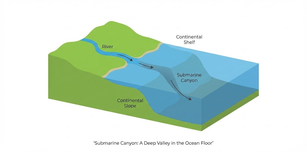
You have walked across the gentle shelf. Suddenly, the ground drops away beneath you. You have reached the Shelf Break. Ahead lies the Continental Slope. This is the steep slide that connects the continental shelf to the deep ocean basins.
1. Definition & Characteristics: The gradient here gets sharper, varying between 2° and 5°. The depth plunges rapidly, ranging from 200 meters down to 3,000 meters. This boundary is significant because the bottom of the slope region indicates the true end of the continental landmass.
2. Submarine Canyons: As you descend this slope, you notice massive gashes cutting through the rock, looking like deep valleys. These are Submarine Canyons. Some of these are so massive they are comparable to the Grand Canyon of the Colorado River.
- Formation: These deep valleys often extend from the mouths of large rivers, cutting across the continental shelves and slopes. They are formed by the erosion caused by sediment-laden water (turbidity currents) brought down by rivers.
- Types:
- Small Gorges: Begin at the shelf edge and extend down to great depths (e.g., Oceanographer Canyons).
- River Mouth Canyons: Begin at the mouth of a river and extend over the shelf (e.g., Indus canyons).
- Dendritic Canyons: Deeply cut into the shelf and slope (e.g., off the coast of Southern California).
- Examples: The Hudson Canyon is the best-known submarine Canyon in the world. The largest ones are found in the Bering Sea off Alaska.
3. The Continental Rise: At the base of the steep slope, the descent slows down. The slope levels out to between 0.5° and 1°. This is the Continental Rise. It is essentially a pile of debris—sediments that slid down the slope and piled up at the bottom. With increasing depth, this rise eventually merges into the flat abyssal plain.
Part 3: Abyssal Plains #
Leaving the rise behind, you enter the vast, silent darkness of the Deep Sea Plain, or Abyssal Plain. These are the flattest and smoothest regions on the entire planet.
1. Definition & Depth: These extensive plains lie between the continental margins and the mid-oceanic ridges. The depth here is immense, varying between 3,000 and 6,000 meters. They cover nearly 40% of the entire ocean floor.
2. Formation & Sediments: Why are they so flat? It isn’t because the rock underneath is flat, but because millions of years of sediment have blanketed the irregular topography, burying the hills and valleys.
- Terrigenous Deposits: These are sediments derived from the land (sand, silt, clay) brought by rivers and wind. They are mostly inorganic and found closer to the margins.
- Pelagic Deposits: Covering nearly 75% of the deep sea floor, these consist of organic material (remains of plants and animals called “ooze“) and inorganic material like Red Clay. Red clay is of volcanic origin and covers more than half of the Pacific floor.
3. Scientific & Economic Importance: These plains are not just mud; they are treasure chests.
- Manganese Nodules: Also called polymetallic nodules, these are potato-shaped lumps containing manganese, iron, nickel, copper, and cobalt. India has been given rights to explore these in the Central Indian Ocean Basin.
- Scientific Value: The sediments here hold the history of Earth’s climate and biological evolution.

Part 4: Mid-Oceanic Ridges #
The Narrative: Just when you think the ocean floor is a flat, dead place, you encounter a monster. Rising from the abyss is the longest mountain chain on Earth. It isn’t the Himalayas; it is the Mid-Oceanic Ridge (MOR) system. It stretches for more than 70,000 km (or 75,000 km) through all the major ocean basins.
1. Structure & Characteristics: This is an interconnected chain of mountains submerged under the sea. It is characterized by:
- A central rift system at the crest (a deep crack running down the middle).
- A fractionated plateau and flank zone.
- Peaks that can rise 2,500 m, sometimes even reaching the surface to form islands like Iceland (part of the Mid-Atlantic Ridge).
2. Formation Mechanism (The Conveyor Belt): This is where the Earth makes new crust.
- Divergent Boundaries: The ridges form where tectonic plates are moving apart (diverging).
- upwelling Magma: As the plates pull apart, molten rock (magma) from the mantle rises to fill the gap.
- Sea Floor Spreading: The magma cools and solidifies to form new ocean crust. This new crust is then pushed away from the ridge as more magma rises. This process, proposed by Harry Hess, is called Seafloor Spreading.
3. Volcanism & Seismicity: The rift system at the crest is a zone of intense volcanic activity.
- Volcanoes: These are mid-oceanic volcanoes. The lava here is basaltic, meaning it is less viscous and spreads easily.
- Magnetic Striping: As the magma solidifies, it records the Earth’s magnetic field. Since the Earth’s magnetic poles flip over time, the seafloor shows parallel “stripes” of magnetic polarity on either side of the ridge. This is a key proof of Plate Tectonics.
4. Associated Features:
- Abyssal Hills: Flanking the ridges are submerged volcanic mountains. If they are pointed, they are Seamounts (e.g., Emperor Seamount). If they are flat-topped (eroded by waves before sinking), they are Guyots,.
5. Major Ridge Systems:
- Atlantic: The Mid-Atlantic Ridge runs North-South, mirroring the ‘S’ shape of the ocean.
- Indian Ocean: Features the Carlsberg Ridge, Socotra-Chagos Ridge, and Seychelles Ridge.

From the resource-rich shelves where we fish and drill for oil, down the steep slopes and canyons, across the flat abyssal plains covered in ancient clay, to the fiery ridges where the Earth is born anew—the ocean floor is a dynamic, living entity. Understanding this relief is key to understanding the distribution of continents, oceans, and the resources that power our world.
UPSC Mains Subjective Previous Year Questions #
- 2020: Discuss the geophysical characteristics of Circum- Pacific Zone.
- 2017: Why are the world’s fold mountain systems located along the margins of continents? Bring out the association between the global distribution of Fold Mountains and the earthquakes and volcanoes.
Related Latest Current Affairs #
- November 2025: Activity at Axial Seamount (Mid-Oceanic Ridge Volcano) Recent geological activity was reported at the Axial Seamount, an underwater shield volcano located on the Juan de Fuca Ridge (a mid-ocean spreading center). It features a large caldera and hydrothermal vents supporting chemosynthetic life, serving as a natural laboratory for studying ridge volcanism and new crust formation.
- October 2025: India Secures Exploration Contract for Carlsberg Ridge India signed a 15-year contract with the International Seabed Authority (ISA) to explore Polymetallic Sulphides (PMS) in the Carlsberg Ridge, a slow-spreading Mid-Oceanic Ridge in the Indian Ocean. This region features rugged topography and hydrothermal vents formed by the divergence of the Indian and Arabian tectonic plates.
- October 2025: NITI Aayog’s Roadmap for Deep-Sea Fisheries NITI Aayog released a strategy to harness resources beyond the Continental Shelf, specifically targeting the Exclusive Economic Zone (EEZ) and high seas. The report highlights the under-exploited potential of deep-sea resources (like lanternfish) found in waters deeper than 200 meters, distinguishing between shelf and deep-ocean fishing zones.
- August 2025: Notification of Offshore Area Atomic Minerals Concession Rules The Ministry of Mines notified new rules to regulate the mining of atomic minerals (like Uranium and Thorium) in India’s Continental Shelf and EEZ. This creates a legal framework for extracting mineral resources from the submerged extensions of the continent.
- June 2025: Geological Study of Arabian Sea Features (Indus Canyon) Articles discussing the Arabian Sea highlighted its distinct bottom relief features, including the Indus Submarine Canyon and the Indus Abyssal Cone (a vast sediment fan on the abyssal plain). These features are shaped by massive sedimentation from the Indus River, demonstrating the link between continental erosion and deep-sea deposition.
- June 2025: Development of India’s Polar Research Vessel (PRV) India signed an MoU to develop a Polar Research Vessel capable of deep-sea exploration and ocean floor mapping. The vessel will be equipped with seismic profilers and multibeam sonar to study seabed topography, including ridges and basins, in polar and tropical waters.
- February 2025: Deep Ocean Mission and Matsya-6000 Updates on the Deep Ocean Mission highlighted the Matsya-6000 submersible, designed to explore the Abyssal Plains (up to 6,000 meters depth). The mission targets Polymetallic Nodules (manganese nodules) scattered across the flat deep-ocean floor of the Central Indian Ocean Basin.
- December 2024: Imaging of Hydrothermal Vents in Indian Ocean Indian oceanographers captured images of active hydrothermal vents at a depth of 4,500 meters. These fissure-like features are typically associated with Mid-Oceanic Ridges and are key sites for the formation of mineral deposits and unique deep-sea ecosystems.