The Butterfly Effect of the Pacific Imagine standing in the middle of a sun-baked agricultural field in Maharashtra, India, watching a farmer look anxiously up at a cloudless sky. The earth is parched, the crops are wilting, and the village well is running dangerously low. You might wonder: what invisible force is causing this devastating drought? The answer does not lie in the skies above India. It lies thousands of kilometres away, deep in the waters of the Pacific Ocean.
For a UPSC aspirant, understanding geography is not merely about memorising maps; it is about uncovering the invisible, interconnected gears that run our planet. Today, we embark on a journey to decode the world’s most powerful climate engines: El Niño, La Niña, and the Indian Ocean Dipole (IOD). These are not just abstract oceanographic terms; they are the ultimate dictators of global food security, economic inflation, and the survival of millions of people.
The Walker Circulation – The Normal Pulse of the Planet #
To understand when the ocean misbehaves, we must first understand how it behaves normally. Our story begins in the vast expanse of the Equatorial Pacific Ocean, a water body so massive it covers almost a third of the Earth. In a “normal” year, a fascinating atmospheric conveyor belt operates across the Pacific. Near the Equator, the Trade Winds blow steadily from the east (the coast of South America) towards the west (towards Indonesia and Australia).
Think of these winds as giant invisible brooms sweeping across the ocean surface. As they sweep westward, they push the warm surface waters of the Pacific along with them.
- The Western Pacific (Indonesia/Australia): Because the warm water is pushed westward, it piles up near Indonesia and northern Australia, creating a massive “warm pool.” The ocean level here is actually physically higher than in the east. This warm water heats the air above it, causing the air to rise and form massive convective thunderstorms. This guarantees heavy, life-giving rainfall for Southeast Asia and northern Australia.
- The Eastern Pacific (Peru/Ecuador): Meanwhile, on the other side of the ocean, off the coast of Peru, the warm surface water has been pushed away. To fill this void, cold, incredibly nutrient-rich water from the deep ocean floor is sucked up to the surface. This process is called upwelling.
The Economic Miracle of upwelling: This cold, upwelled water off the Peruvian coast is a biological goldmine. It brings up nitrates and phosphates from the deep, triggering explosive blooms of phytoplankton. This sustains one of the richest fishing grounds on Earth. The anchovy fisheries here dictate global fishmeal prices. This entire continuous loop of rising warm air in the west, high-altitude winds returning east, sinking cold air in the east, and Trade Winds completing the cycle at the surface is called the Walker Circulation (or Walker Cell). It is the normal, healthy heartbeat of our planet.

El Niño – The Christ Child Arrives #
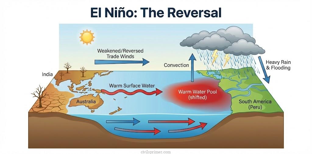
But the ocean is a fickle beast. Every three to seven years, around Christmas time, the fishermen off the coast of Peru notice something terrifying: the ocean water starts turning unusually warm. Because it arrives in December, the local Spanish-speaking fishermen named this phenomenon El Niño, which translates to ‘The Little Boy’ or ‘The Christ Child’.
The Mechanism of the Menace: During an El Niño year, the planet’s atmospheric gears mysteriously jam. The normally strong Trade Winds suddenly weaken, and sometimes even reverse. Without the winds to hold it back, the massive pile of warm water in the western Pacific sloshes back eastward across the ocean, like water in a bathtub, towards the coastlines of Peru and Ecuador. This eastward movement of warm water is carried by the equatorial counter-current. The consequences of this warm water invasion are catastrophic:
- The Death of Fisheries: The thick layer of warm water pushes down the Thermocline (the boundary between warm surface water and cold deep water), effectively cutting off the upwelling of cold, nutrient-rich water. Without nutrients, the phytoplankton die, the fish starve or migrate, and the multi-billion-dollar Peruvian fishing industry collapses.
- Global Weather Reversal: The massive thunderstorms that normally hover over Indonesia and Australia follow the warm water eastward to the central Pacific and South America.
- The Arid turns Wet: The normally dry deserts of Peru, Ecuador, and California are suddenly battered by heavy rains and intense floods.
- The Wet turns Arid: Conversely, Indonesia, Australia, and India are robbed of their moisture, leading to severe droughts and devastating forest fires.
ENSO (El Niño Southern Oscillation): Meteorologists noticed that this oceanic warming (El Niño) is perfectly mirrored by a flip in atmospheric pressure called the Southern Oscillation. Normally, pressure is low in the west (Tahiti/Darwin) and high in the east. During El Niño, this pressure flip-flops. Together, the ocean warming and the atmospheric pressure shift are known scientifically as ENSO.
La Niña – The Little Girl’s Vengeance #
After an El Niño event, the ocean eventually tries to correct itself. But sometimes, it overcorrects. This extreme rubber-band effect is called La Niña, meaning ‘The Little Girl‘ in Spanish. If El Niño is the reversal of normal conditions, La Niña is the exaggeration of normal conditions.
- Hyperactive Trade Winds: The easterly Trade Winds become violently strong.
- Extreme upwelling: They push almost all the warm surface water intensely to the west, causing an abnormal, massive accumulation of freezing cold water in the central and eastern Pacific Ocean.
The Global Impact of La Niña: While the fishermen in Peru rejoice at the return of intensely cold, nutrient-rich waters, the rest of the world braces for impact.
- Supercharged Monsoons: For India, Southeast Asia, and Australia, La Niña brings abnormally heavy monsoon rains, often resulting in widespread, destructive flooding.
- Hurricane Fuel: La Niña alters the upper-level atmospheric winds globally, drastically increasing the frequency and destructive power of hurricanes in the Atlantic Ocean. For example, the incredibly deadly Hurricane Mitch in 1998 was a direct result of a strong La Niña.
- Winter Extremes: It causes unusually cold winters in western Canada and extreme winter droughts in the southern United States.
The IOD (Indian Ocean Dipole) #
For a long time, Indian meteorologists were puzzled. They noticed that El Niño usually caused severe droughts in India. However, during the devastating global El Niño of 1997, India miraculously received normal monsoon rainfall. Why didn’t India dry up?
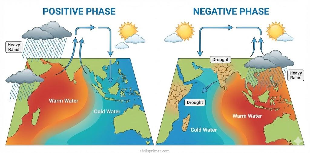
The answer was discovered in 1999: The Indian Ocean has a mind of its own. This homegrown phenomenon is called the Indian Ocean Dipole (IOD). Just like ENSO in the Pacific, the IOD is a seesaw of sea surface temperatures, but it happens right in our backyard—between the western Indian Ocean (the Arabian Sea, near Africa) and the eastern Indian Ocean (south of Indonesia).
1. Positive IOD (The Monsoon Saviour): During a Positive IOD, the winds over the Indian Ocean blow from east to west.
- This pushes warm water towards the African coast, making the Arabian Sea much warmer than usual.
- Simultaneously, cold water rises near Indonesia, making the eastern Indian Ocean colder and drier.
- Impact on India: The unusually warm Arabian Sea generates massive evaporation, sending heavy, moisture-laden winds crashing into the Indian subcontinent. A Positive IOD brings incredibly good, sometimes heavy, rainfall to India, acting as a powerful buffer that can completely cancel out the negative effects of an El Niño. It also boosts cyclogenesis (cyclone formation) in the Arabian Sea.
2. Negative IOD (The Double Whammy): In a Negative IOD year, the seesaw tilts the other way. The waters around Indonesia become abnormally warm, while the Arabian Sea cools down.
- Impact on India: This pulls the moisture away from the Indian subcontinent towards Indonesia and Australia. For India, a Negative IOD suppresses the monsoon and suppresses cyclogenesis in the Arabian Sea, leading to delayed or deficient rainfall. If a Negative IOD coincides with an El Niño, it is a recipe for a catastrophic, widespread drought in India.
Impacts: Demographics, Livelihoods, and the Climate Crisis #
As an aspiring civil servant, you must realize that El Niño and the IOD are not just ocean temperatures; they are the invisible hands that steer the Indian economy and dictate social stability.
The Demographic Vulnerability of India: India is heavily dependent on the Southwest Monsoon. Consider the sheer scale of the demographic reliance: roughly 64 percent of the people of India depend on agriculture for their livelihood. Furthermore, nearly 50 per cent of the rural workforce is concentrated entirely in agricultural activities. Because large parts of Indian agriculture lack robust irrigation infrastructure, the rural economy is acutely sensitive to the whims of the Pacific Ocean. When an El Niño event triggers a meteorological drought (rainfall deficiency of ≥26%), the socio-economic domino effect is brutal:
- Economic Shocks: During severe drought years, agricultural contributions to India’s Gross Domestic Product (GDP) have dipped by over 3.1 percent, resulting in agricultural income losses of tens of thousands of crores. Since agriculture contributes roughly 14% to the overall national economy, rural distress instantly drags down national growth.
- Food Inflation & Scarcity: Deficient rainfall leads to massive crop failures in staples like rice, wheat, and pulses. This supply shock creates immediate food inflation, disproportionately hurting the urban and rural poor.
- Distress Migration and Social Strain: When crops fail, rural employment evaporates. This triggers waves of ‘distress migration‘, where destitute farmers and laborers flee to already overburdened mega-cities in search of wage labor. This exacerbates urban slums, strains municipal water resources, and creates profound social tension.
The Climate Change Threat: Today, anthropogenic global warming is injecting chaos into these natural cycles. The Indian Ocean is warming at an alarming rate—rising by 1°C on average between 1951 and 2015, which is notably higher than the global average. Because the oceans are absorbing more heat from greenhouse gases, the very dynamics of ocean currents and phenomena like ENSO and IOD are altering.
El Niño and La Niña events are becoming more extreme and less predictable. A rapidly warming Indian Ocean affects the Atlantic Meridional Overturning Circulation (AMOC) and shifts regional rain belts, meaning the historical predictability of the monsoon that Indian farmers have relied on for millennia is vanishing.
Conclusion: The Connected Globe #
From the humble anchovy fishermen of Peru to the sugarcane farmers of Maharashtra, the globe is intricately connected by invisible rivers of warm and cold ocean water. Understanding El Niño, La Niña, and the IOD allows us not only to predict the weather but to build resilient safety nets—through drought management, strategic crop diversification, and climate-adaptive infrastructure—to protect the poorest demographics from the temper tantrums of the global seas.
Mains PYQs #
- (2014) GS Paper 3: Drought has been recognized as a disaster in view of its spatial expanse, temporal duration, slow onset, and lasting effects on vulnerable sections. With a focus on the September 2010 guidelines from the National Disaster Management Authority (NDMA), discuss the mechanisms for preparedness to deal with likely El Niño and La Niña fallouts in India.
- (2014) GS Paper 1: Most of the unusual climatic happenings are explained as an outcome of the El-Niño effect. Do you agree?
Related Latest Current Affairs #
- (October, 2025): Seas Rising Faster Around Lakshadweep and Maldives Recent studies – using Coral microatolls revealed that sea-level rise in the central Indian Ocean has been accelerating since the late 1950s. The research highlighted that periods of Coral growth interruption in these regions strongly coincided with major marine phenomena, specifically El Niño and negative Indian Ocean Dipole (IOD) events.
- (September, 2025): Changing El Niño-Monsoon Relationship – Analyses of India’s recent extreme monsoon-related weather events indicated a shifting dynamic in traditional climate impacts. Researchers noted a weakening correlation between El Niño and reduced monsoon rainfall over India, which is being driven by broader changes in global atmospheric circulation patterns and warming temperatures.
- (July, 2025): Global Drought Hotspots Report (2023-2025) – The UN Convention to Combat Desertification (UNCCD) released a report highlighting intensifying drought conditions globally, terming them “slow-moving catastrophes.” It identified the powerful 2023–2024 El Niño event as a major amplification factor that exacerbated dry conditions and crop failures across critical agricultural belts worldwide.
- (January, 2025): Global Warming and Record Heat of 2024 – As 2024 was declared the warmest year on record, climate reports emphasized the significant role of marine phenomena in this temperature surge. A strong El Niño event amplified ocean temperatures, working in tandem with greenhouse gas emissions to push global surface averages well above historical baselines.
- (December, 2024): Early Signals of El Niño Return Forecasted Climate models and ocean observations – detected early signals indicating a possible return of El Niño conditions by 2026. This transition in the El Niño–Southern Oscillation (ENSO) cycle is expected to occur as the abnormal warming of surface waters in the equatorial Pacific gradually weakens the prevailing La Niña conditions.