The Engine’s Fuel and the Great Inequality #
Imagine the Earth not just as a rock, but as a giant, breathing engine. Like any engine, it needs fuel to move. That fuel is Insolation (incoming solar radiation). However, there is a fundamental problem: the Earth is spherical. The Equator receives a surplus of heat, like a pot boiling on a stove, while the Poles are in a constant energy deficit, freezing in the shadows.
Nature hates inequality. To fix this imbalance, the atmosphere attempts to transfer heat from the warm Equator to the cold poles. This movement of air to redistribute heat is what we call Atmospheric Circulation. But air doesn’t just move; it follows the rules of Pressure.
- The Rule of Heat: When air heats up, it expands, becomes lighter, and rises. This creates a Low-Pressure void.
- The Rule of Cold: When air cools, it compresses, becomes heavy, and sinks. This creates a giant pile of air, or High-Pressure.
The Golden Rule of Wind: Wind always runs from a crowded High-Pressure area to an empty Low-Pressure area to fill the gap.

Coriolis Force – The Spinning Dancer #
If the Earth were standing still, the wind would simply blow in a straight line from the High-Pressure Poles to the Low-Pressure Equator. But the Earth is a spinning dancer, rotating from West to East.This rotation creates a “mysterious” deflective force called the Coriolis Force.
- The Northern Hemisphere Rule: Any moving object (wind) is deflected to its Right.
- The Southern Hemisphere Rule: Any moving object (wind) is deflected to its Left.
- The Twist: This force is zero at the Equator (where the dancer’s spin feels slowest) and maximum at the Poles.
Because of this spin, winds never cross isobars (pressure lines) at right angles; they get twisted. In the upper atmosphere, where friction is low, they get twisted so much they flow parallel to the isobars. We call these Geostrophic Winds.

The Seven Belts of the Earth #
The interaction of heat (thermal factors) and the Earth’s rotation (dynamic factors) creates seven distinct pressure belts around the globe. Let’s tour them from the center to the top.
- The Equatorial Low-Pressure Belt (The Doldrums)
- Location: 10°N to 10°S. The Story: Here, the sun beats down relentlessly. The air gets hot and rises (convection). Because the air is rising vertically, there is very little horizontal wind. It is a zone of dead calm, which sailors historically feared because their ships would get stuck. They named it the Doldrums. This rising air creates massive Cumulonimbus clouds and afternoon thunderstorms. It is also where Trade Winds from both hemispheres crash into each other, forming the Inter-Tropical Convergence Zone (ITCZ).
- The Sub-Tropical High-Pressure Belts (The Horse Latitudes)
- Location: 30°N and 30°S. The Story: Remember the air that rose at the Equator? It travels poleward in the upper atmosphere. But as it travels, it cools down and gets blocked by the Earth’s rotation (Coriolis effect). It piles up and sinks at around 30° latitude. Sinking air means high pressure, clear skies, and no rain. This is why most of the world’s hot deserts (Sahara, Thar, Atacama) are found here. Why “Horse Latitudes”? Ancient sailors, stuck in these calm, windless waters, supposedly had to throw their horses overboard to conserve water or lighten the load to catch a faint breeze.
- The Sub-Polar Low-Pressure Belts
- Location: 60°N and 60°S. The Story: This is a battleground. The warm air coming from the sub-tropics clashes with the cold air coming from the poles. When they collide, the warmer air is forced to rise, creating a low-pressure zone. This rising air creates storm fronts and cyclonic activity.
- The Polar Highs
- Location: North and South Poles. The Story: It is bitterly cold. The air is dense, heavy, and freezes. It sinks continuously, creating a permanent thermal High-Pressure cap over the poles.

The Planetary Highways (Primary Winds) #
Connecting these pressure belts are the permanent winds—the highways of the atmosphere that blow throughout the year.
- The Reliable Merchants: Trade Winds – Blowing from the Sub-Tropical Highs toward the Equatorial Low.
- Direction: In the North, they blow from the North-East. In the South, from the South-East.
- Significance: They are steady and reliable (hence “Trade” winds, aiding early maritime trade). They pick up moisture over oceans and dump heavy rains on the eastern coasts of continents, leaving the western coasts dry.
- The Roaring Travelers: Westerlies – Blowing from the Sub-Tropical Highs toward the Sub-Polar Lows.
- Direction: South-West to North-East (NH) and North-West to South-East (SH).
- Significance: They bring varying weather and cyclonic rain to the western margins of continents (like Europe).
- The Southern Beast: In the Southern Hemisphere, there is barely any land to stop them. They become violent and loud. Sailors call them the Roaring Forties, Furious Fifties, and Shrieking Sixties based on their latitudes.
- The Frozen Breath: Polar Easterlies – Blowing from the Polar Highs toward the Sub-Polar Lows.
- Direction: They blow from the East.
- Significance: They are cold, dry, and stable, blowing from the freezing ice caps.

Local Winds: The Local Mood Swings #
While planetary winds are the climate’s personality, local winds are its mood swings. They change based on local geography and time.
Land and Sea Breezes: The Daily Rhythm
- Daytime (Sea Breeze): The land heats up faster than the sea. Low pressure forms over the land. Cool air rushes in from the sea.
- Nighttime (Land Breeze): The land loses heat quickly. High pressure forms over the land. The sea is still warm (Low pressure). Wind blows from land to sea.
Valley and Mountain Breezes: The Mountain’s Breath
- Day (Valley Breeze): The sun heats the mountain slopes. Air rises up the slope (upslope wind).
- Night (Mountain Breeze, Katabatic): The slopes cool down. Heavy, dense air drains down into the Valley (downslope wind).
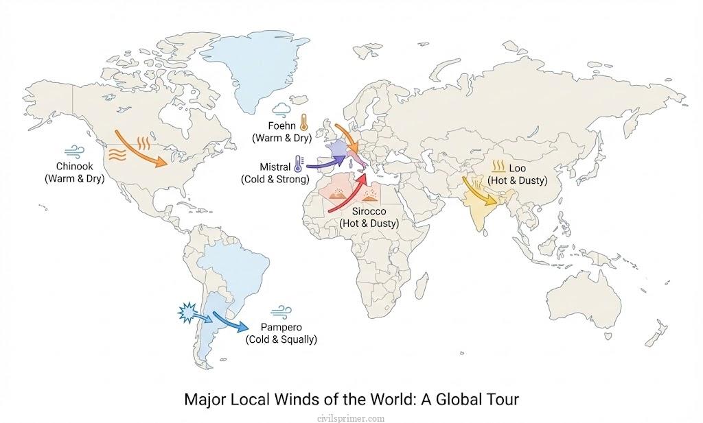
Specific Local Winds: The Famous Characters
- Loo: A hot, dry, and punishing wind that blows over the plains of Northern India and Pakistan in summer afternoons. It can cause sunstroke.
- Chinook (The Snow Eater): A warm, dry wind flowing down the Rockies in the USA/Canada. It is beneficial because it melts the snow in winter, allowing cattle to graze.
- Foehn: Similar to Chinook, but found in the Alps (Europe). It destroys sour grapes but helps ripen the harvest.
- Mistral: A cold, dangerous wind blowing from the Alps down to the Mediterranean (France). It brings Blizzards.
- Sirocco: A hot, dusty wind from the Sahara Desert blowing across the Mediterranean to Europe. It picks up moisture and creates “Blood Rain” (rain with red dust).
UPSC Mains Subjective Previous Years Questions #
• 2016 → Discuss the concept of air mass and explain its role in macro-climatic changes.
• 2014 → Tropical cyclones are largely confined to the South China Sea, Bay of Bengal and Gulf of Mexico. Why?
• 2013 → Major hot deserts in northern hemisphere are located between 20-30 degree north and on the western side of the continents. Why?
• 2013 → Bring out the causes for the formation of heat islands in the urban habitat of the world.
Answer Writing Minors #
Introduction : “The unequal distribution of solar insolation over the Earth’s surface creates a latitudinal heat imbalance, resulting in variations in atmospheric pressure that drive the motion of air,. This atmospheric circulation, functioning through planetary winds (Trade Winds, Westerlies) and local winds, acts as a primary mechanism to redistribute heat and moisture from energy-surplus tropical regions to energy-deficit polar regions, thereby maintaining the Earth’s global heat budget,,.”
Conclusion : “In conclusion, the general circulation of the atmosphere not only dictates global climate zones and precipitation patterns but is also responsible for setting in motion ocean water circulation,. Whether manifested as macro-scale planetary winds or micro-scale local winds, this system is fundamental to sustaining the hydrological cycle and influencing socio-economic activities ranging from agriculture to navigation,.”
Related Latest Current Affairs #
- November 2025: Changing Patterns of Western Disturbances Recent studies and IMD forecasts highlighted the increasing frequency and extended seasonality of Western Disturbances (extra-tropical cyclones driven by Westerlies). While crucial for Rabi crops (wheat) in North India (economic utility), their erratic behaviour is triggering disasters like Flash Floods, landslides, and hailstorms in the Himalayas and Delhi.
- November 2025: Formation of Cyclones Montha and Shakhti The IMD tracked Cyclone Montha (Bay of Bengal) and Cyclone Shakhti (Arabian Sea). These tropical cyclones are influenced by planetary winds (Trade Winds) and sea surface temperatures. Their trajectories illustrate the impact of atmospheric circulation on coastal safety and the need for disaster management in India’s economic hubs along the coast.
- October 2025: El Niño’s Link to Extreme Rainfall A new study revealed that El Niño (caused by the weakening of Trade Winds in the Pacific) increases the probability of extreme daily rainfall in Central India by 50%, despite suppressing overall monsoon volume. This alters flood risks, impacting agriculture and disaster planning in the Indian economy.
- May 2025: Early Onset of Southwest Monsoon The Southwest Monsoon arrived early in Kerala, driven by the strengthening of the Somali Jet (a cross-equatorial low-level Jet Stream) and the Mascarene High pressure belt. These planetary wind systems are the backbone of the Indian economy, determining agricultural output and water security.