The Odyssey of a Water Drop: From Vapor to Rain #
Our story begins not with water as we see it, but with water as a ghost—Water Vapor. This invisible gas is the protagonist of our weather system. It varies in presence, making up anywhere from 0% to 4% of the atmosphere by volume. Imagine the atmosphere is a giant sponge.
- Absolute Humidity: This is the actual weight of water held in the sponge (grams of water per cubic meter of air). It changes depending on where you are—highest over oceans, lowest over continents.
- Relative Humidity (RH): This is the tricky part. It tells you how “full” the sponge is compared to its total capacity.
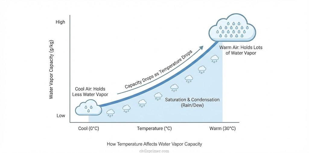
- The Temperature Twist: Warm air is a big sponge; it can hold a lot of water. Cold air is a tiny sponge.
- If you have a half-full big sponge (Warm Air, 50% RH) and you suddenly shrink it (Cool the air), the sponge becomes full (100% RH) even though you didn’t add a drop of water.
The Climax: The Dew Point When the air cools down enough that the “sponge” can no longer hold the water, it reaches 100% Relative Humidity. This specific temperature is called the Dew Point. Any cooling beyond this point forces the ghost to reveal itself—condensation begins.
Condensation: The Great Transformation #
Condensation is the magical act where water vapor turns back into liquid. But it creates a paradox: Energy is released. When water evaporates, it steals heat (Latent Heat of Vaporization). When it condenses, it releases that heat back into the atmosphere (Latent Heat of Condensation). This released heat is the fuel that powers massive storms and cyclones,.
Forms of Condensation : Depending on where and how the cooling happens, condensation wears different masks:
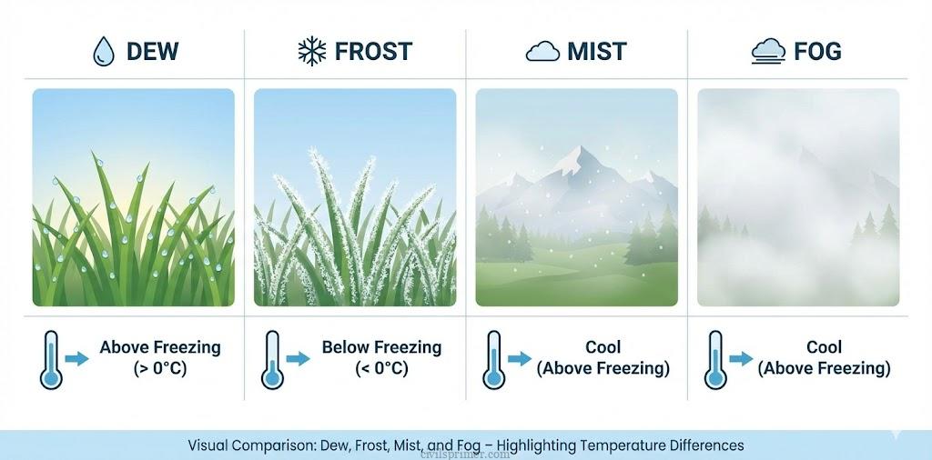
- Dew (The Morning Jewels):
- Scene: A long, cold winter night. The ground cools down faster than the air.
- Action: Moisture condenses directly onto cold surfaces like grass or stones.
- Rule: The Dew Point must be above freezing point (>0∘C).
- Frost (The Frozen Jewels):
- Fog and Mist (The Ground Clouds):
- Fog: A cloud that decided to visit the ground. Visibility is very poor (less than 1 km). It happens when a large mass of air cools down suddenly.
- Mist: Fog’s wetter cousin. It has more moisture, and the water droplets are larger. Common in mountains where rising warm air meets cold slopes.
- The Villain: Smog = Fog + Smoke (pollution).
Clouds: The Sky Castles #
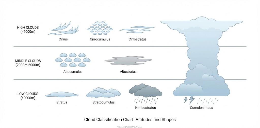
When air rises, it expands and cools (Adiabatic Cooling). If it cools enough, water vapor grabs onto tiny dust particles (Hygroscopic Nuclei) and forms Clouds. Clouds are classified by how high they live and what they look like.
- Cirrus: The High Flyers
- Altitude: 8,000 – 12,000m.
- Appearance: Thin, feathery, wispy.
- Composition: Made entirely of ice crystals. They don’t give rain but often signal a change in weather.
- Cumulus: The Cotton Balls
- Altitude: 4,000 – 7,000m.
- Appearance: Look like cauliflower or cotton wool with a flat base.
- Personality: Fair-weather friends, unless they grow huge.
- Stratus: The Blanket
- Appearance: Layered sheets covering the whole sky.
- Personality: Boring weather. They bring dull days but usually no heavy rain.
- Nimbus: The Rainmakers
- Appearance: Dark, grey, shapeless masses. They hang low, sometimes touching the ground.
- Action: “Nimbus” literally means rain. If you see them, get an umbrella.
Precipitation: The Fall #
When cloud droplets get too heavy for gravity to ignore, they fall.
- Rain: Liquid water drops (size > 0.5 mm).
- Snow: If the air is freezing all the way down, vapor turns into hexagonal ice crystals.
- Sleet: Frozen raindrops. This happens when rain falls through a layer of freezing air near the ground and refreezes into ice pellets.
- Hail: The violent one. In massive thunderstorms, updrafts toss frozen raindrops back up into the clouds repeatedly. They gather more layers of ice (like an onion) until they are too heavy and crash down as hard stones.
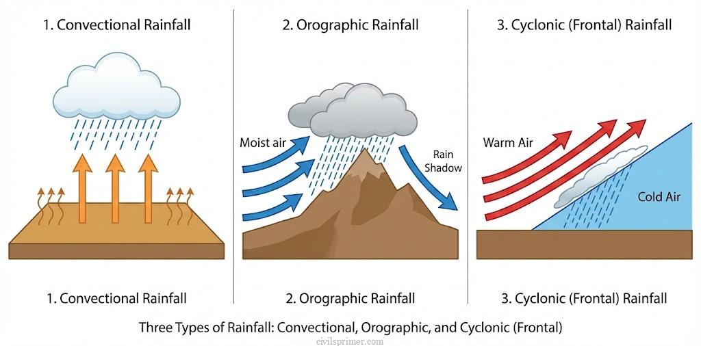
Types of Rainfall: The Three Ways to Make it Rain #
Air needs to rise to cool down and make rain. How it rises defines the “Type” of rainfall.
- Convectional Rainfall : (The “4 O’Clock Rain”)
- The Story: The sun heats the ground intensely. The air gets hot, becomes light, and rises like a hot air balloon. As it rises, it cools and forms massive Cumulonimbus clouds.
- The Climax: Sudden, heavy downpour with thunder and lightning. It usually happens in the afternoon.
- Location: Very common in the Equatorial regions and interiors of continents in summer.
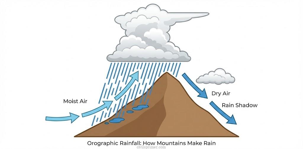
- Orographic / Relief Rainfall : (The Mountain Barrier)
- The Story: Warm, moist wind (like the Monsoon) runs into a mountain. It has nowhere to go but up. As it climbs the slope (Windward side), it cools and dumps all its rain.
- The Tragedy: By the time the wind crosses the peak and goes down the other side (Leeward side), it is dry. This dry side is called the Rain Shadow Area.
- Example: Mumbai (Windward) gets heavy rain; Pune (Leeward) gets much less.
- Cyclonic Rainfall / Frontal Rainfall (The Clash of Air Masses)
- The Story: A warm air mass meets a cold air mass. They don’t mix. The lighter warm air is forced to rise over the heavier cold air.
- The Result: As the warm air rises gently over the cold air, it cools and forms clouds, leading to long-lasting, moderate showers. This is common in temperate regions.
Cloudburst ⛈️ An Introduction #
magine you are holding a bucket full of water. Normally, you pour it out slowly through a sieve (normal rainfall). But what if someone bumps into you, or you simply flip the bucket upside down? The water hits the ground in one massive, violent splash. This is a Cloudburst. It isn’t just “heavy rain.” It is an intense, torrential downpour brought by a thunderstorm that lasts for a relatively short duration—a few minutes to a few hours. How does this happen?
1. The Mountain Trap (Orographic Lock): Imagine a warm, moist air mass moving happily along until it hits a massive wall—the Himalayas or the Western Ghats. The air has nowhere to go but up.
- The Ascent: The air is forced to rise rapidly (Orographic upliftment).
- The Trap: As it rises, it cools down. If the moisture content is high, it condenses into a massive Cumulonimbus cloud (the thundercloud).
- The Burst: The cloud gets so heavy and tall that it dumps all its moisture on the windward side instantly. This is why places like Cherrapunji and Mawsynram get such heavy rain—they are traps for moist winds.
2. The Traffic Jam in the Sky (Dynamic Factors): Sometimes, the “highway” of the upper atmosphere—the Jet Stream—gets blocked.
- The Story of 2010: In 2010, a strong high-pressure system stuck over Russia acting like a roadblock. It stalled the Sub-Tropical Jet Stream.
- The Collision: The monsoon winds from the south, carrying warm water from the Indian Ocean, tried to move north but hit this “air wall.” With nowhere to go, the clouds sat over Jammu and Kashmir and Pakistan, dumping vast amounts of rain, causing devastating floods.
3. Related Hazards ⚠️
- Flash Floods: Cloudbursts lead to immediate Flash Floods.
- GLOFs: In the Himalayas, these bursts can overfill glacial lakes, causing Glacial Lake Outburst Floods (GLOFs). A recent example is the Nanda Devi glacier incident in Joshimath, Uttarakhand, where a portion of the glacier broke off, triggering disasters downstream.
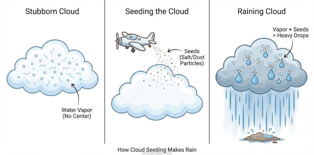
Artificial Rain 🌧️ The Emerging Star #
Imagine a massive cloud floating over a parched village. It is full of moisture, yet it refuses to rain. Why? Because the water vapor inside is like a “ghost”—it has no physical body to hold onto. In nature, dust and salt particles act as Hygroscopic Nuclei, the tiny “skeletons” that water vapor clings to, transforming into droplets. Without them, the cloud is just a floating Mist. The Human intervenes by Cloud Seeding. When nature fails, humans step in as the “Cloud Shepherd.” We fly aircraft into these stubborn clouds and sprinkle them with specific compounds (mimicking nature’s dust and salt).
- The Compounds: The text highlights that dust and salt particles naturally act as Hygroscopic Nuclei. In artificial scenarios, we inject these “nuclei” to force the vapor to condense.
- The Reaction: Once the nuclei are introduced, water vapor rapidly latches onto them. This condensation releases Latent Heat, warming the air and causing the cloud to grow taller and heavier, eventually forcing gravity to pull the droplets down as rain.
Compounds used in Artificial Rain at the stage
| Stage | Purpose | Common Compounds |
|---|---|---|
| Agitation | Stimulate cloud formation | Calcium Carbide, Calcium Oxide, Ammonium Nitrate |
| Building-up | Increase cloud density | Sodium chloride (Salt), Urea, Kitchen salt |
| Seeding/Bombardment | Trigger precipitation | Silver Iodide, Dry ice, Potassium iodide |
Why Do We Need This? (The Future Crisis)
The need is desperate. We are facing a future of “Day Zero”—a day when city taps run dry, a reality already faced by Cape Town and threatened in Indian cities like Chennai and Delhi.
- The Data: Nearly 600 million Indians face high to extreme water stress.
- The Imbalance: While some areas face Flash Floods due to “Cloudbursts” caused by excess pollutants acting as nuclei, other areas suffer severe drought. We need artificial rain to correct this mal-distribution.
Related Latest Current Affairs #
- October 2025: Cloud Seeding Trials in Delhi (Artificial Rain) The Delhi government, in collaboration with IIT-Kanpur, conducted Cloud Seeding trials to induce artificial rain. This process involves dispersing chemicals like Silver Iodide (AgI) and Sodium Chloride to act as condensation nuclei, encouraging water vapour to condense into droplets in clouds with low moisture content (15–20%).
- September 2025: Rising Instances of ‘Mini Cloudbursts’ The IMD highlighted a rise in “Mini Cloudbursts,” defined as rainfall intensity ≥5 cm/hour over a small area (20–30 sq km). These are often driven by orographic lifting in hilly regions and Urban Heat Island effects in cities, leading to intense localized precipitation.
- July 2025: Launch of GOSAT-GW Satellite (Space Mission) Japan (JAXA) launched the GOSAT-GW satellite to monitor the global water cycle and greenhouse gases. It carries sensors to observe cloud cover, precipitation trends, and sea surface temperatures, aiding in the study of atmospheric composition and humidity.
- July 2025: Rare ‘Roll Cloud’ Phenomenon A rare Roll Cloud was observed over Portugal. This low-level, tube-shaped cloud forms due to the collision of cool maritime air and hot continental air (creating a boundary for condensation), often detached from the parent thunderstorm cloud.
- June 2025: Cloudbursts in Himachal Pradesh Devastating cloudbursts occurred in Kangra and Kullu. These are extreme rainfall events (≥100 mm/hour) caused by rapid condensation in towering Cumulonimbus clouds, driven by strong convection currents and orographic lifting along steep mountain slopes.
- June 2025: Delhi Artificial Rain Pilot Project The Delhi government launched a pilot to induce rain using Cloud Seeding technology. The project utilizes aircraft to disperse hygroscopic flares into Nimbostratus clouds (rain-bearing clouds) to accelerate coalescence (droplet merger) and trigger precipitation to wash away pollutants.
- May 2025: Changing Patterns of Western Disturbances Recent studies indicated that Western Disturbances—extra-tropical cyclones bringing cyclonic rainfall to North India—are becoming more frequent in summer due to climate change. These systems interact with the monsoon trough, altering precipitation intensity.