The Living Ocean Imagine standing on the golden sands of Marina Beach in Chennai. As you look out at the vast expanse of the Bay of Bengal, you will notice that the water is never truly still. It heaves, it crashes, it pulls back, and it constantly travels. For a UPSC aspirant, the ocean is not merely a water body; it is a dynamic, living entity. Its physical characteristics—temperature, salinity, and density—interact with external cosmic forces from the sun, the moon, and the Earth’s winds to keep it in perpetual motion.
This movement dictates the climate we experience, the fish we eat, the deserts that form on our continents, and the survival of millions living along the coastlines. Broadly, the ocean moves in two directions: horizontally (waves and currents) and vertically (tides and upwelling). Let us embark on a journey to decode the three great movements of the ocean: Waves, Tides, and Currents.
Waves #
Our story begins at the very surface of the water. When you throw a stone into a pond, ripples spread outwards. Similarly, ocean waves are actually the movement of energy, not the water itself, traveling across the ocean surface.
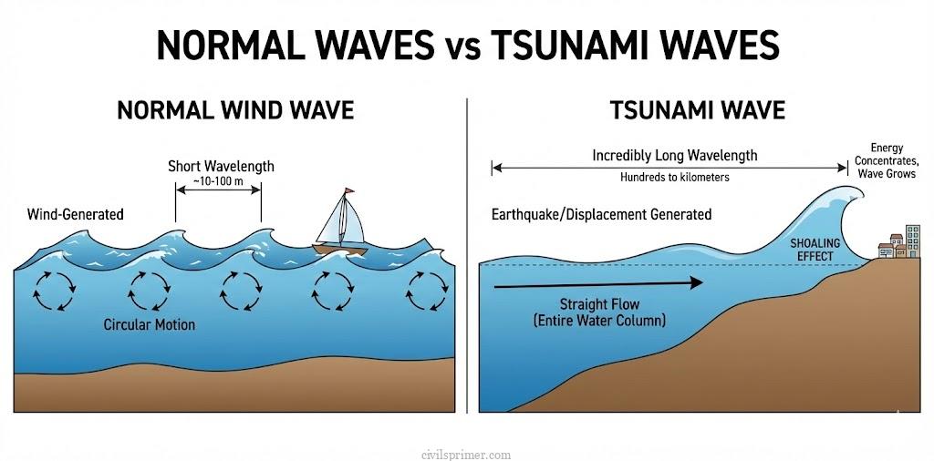
The Mechanics of a Wave: Wind is the invisible engine that provides energy to the waves. As the wind blows across the calm ocean, friction causes small ripples to form, which grow into massive swells as wind speed increases. It is crucial to understand that water particles in a wave only travel in a small circular motion as the wave passes; they do not travel horizontally with the wave. Think of a Mexican wave in a cricket stadium—the people stand up and sit down (vertical motion), but the ‘wave’ travels around the stadium (horizontal energy transfer).
When a wave approaches the shallow waters of a beach, the friction between the dynamic water and the sea floor slows it down. As the depth decreases, the wave’s crest (highest point) outpaces its trough (lowest point), causing the wave to break and dissolve into the surf we play in.
The Tsunami Exception: While normal waves are driven by wind, there is a monster wave driven by the earth itself: the Tsunami (Japanese for “Harbour wave”). Earthquakes, volcanic eruptions, or submarine landslides displace massive volumes of water, creating waves with a wavelength exceeding 500 km. In deep waters, they travel silently at jet speeds (up to 800 km/hr) with very low heights, going completely unnoticed by ships. However, as they enter shallow coastal waters, their speed drops drastically, and their height grows immensely due to the ‘shoaling’ effect, sometimes reaching 15 meters or more as a wall of destruction.
Tides #
Now, let us look beyond the Earth. The ocean’s breath—its daily rise and fall—is dictated by celestial bodies. The periodical rise and fall of the sea level, once or twice a day, is known as a tide. Tides are the result of a delicate cosmic tug-of-war. The primary cause is the gravitational pull of the moon, and to a lesser extent, the sun. But there is a counter-force: the Earth’s centrifugal force, which acts to counterbalance gravity. This creates two tidal bulges on Earth:
- Facing the Moon: The gravitational pull of the moon is strongest here, overpowering the centrifugal force and pulling the water outward to create a bulge.
- Opposite the Moon: On the far side of the Earth, the moon’s gravitational grip is weak. Here, the centrifugal force dominates, throwing the water outward to create a second bulge.
As the Earth rotates through these bulges, coastal regions experience the rhythmic cycle of high tides and low tides. The time between high tide and low tide, when water falls, is called the ebb; when it rises, it is called the flood.
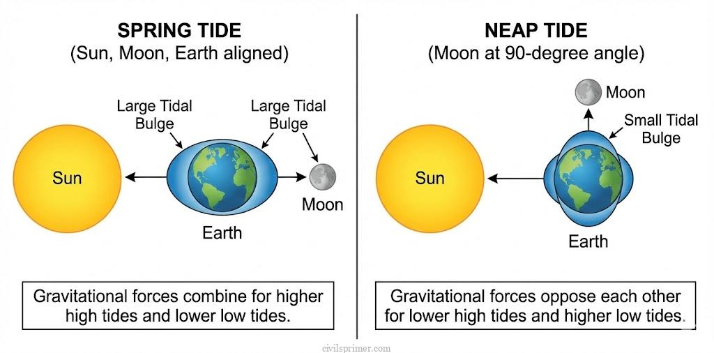
Spring and Neap Tides (The Extremes):
- Spring Tides: Twice a month, during the full moon and new moon, the sun, moon, and Earth align in a straight line (Syzygy). Their combined gravitational pulls reinforce each other, creating unusually high and low tides known as Spring Tides.
- Neap Tides: A week later, the sun and the moon are at right angles to each other relative to the Earth (Quadrature). The sun’s gravitational pull partially cancels out the moon’s pull, resulting in much smaller tidal ranges called Neap Tides.
Socio-Economic Importance of Tides: Tides are highly predictable, which makes them an incredible socio-economic asset, thus useful for –
- Navigation: High tides raise water levels near shores and estuaries, allowing large ocean-going vessels to enter shallow ports safely. The Port of Kolkata (Hooghly) and the Port of London rely heavily on this.
- Fishing: High tides bring massive fish populations closer to the shore, aiding local fishing communities in securing plentiful catches.
- Energy: Tides are a potent source of renewable energy. India has been exploring this with projects like the 3 MW tidal power project at Durgaduani in the Sunderbans (West Bengal).
Major Ocean Currents #
If waves are the heartbeat and tides are the breath, Ocean Currents are the circulatory system of the globe. They are massive rivers of water flowing continuously in a definite path and direction across the oceans. What drives these massive rivers? They are born from a combination of Primary Forces (which initiate movement) and Secondary Forces (which guide the flow):
- Insolation (Solar Heating): The sun heats the water at the Equator, causing it to expand. Thus, ocean levels at the Equator are about 8 cm higher than at the poles, creating a slight slope for water to slide down.
- Prevailing Winds: Trade Winds and Westerlies act as brushes, dragging the surface water along with them through friction.
- Coriolis Force: Because the Earth rotates, water does not flow in a straight line. The Coriolis Force deflects currents to the right in the Northern Hemisphere and to the left in the Southern Hemisphere. This creates massive circular flow patterns known as Gyres.
- Density Differences (Secondary): Cold water is heavier and denser than warm water; highly saline water is denser than fresh water. Dense water sinks at the poles and travels towards the Equator as deep-ocean currents, while warm surface water moves poleward to replace it (The Thermohaline Circulation).
Warm vs. Cold Currents:
- Warm Currents: Originate near the Equator and travel towards the poles. They are typically found on the east coasts of continents in lower and middle latitudes.
- Cold Currents: Bring icy water from the poles towards the Equator. They are predominantly found on the west coasts of continents in lower latitudes.
Mapping the Major Ocean Currents #
1. The Atlantic Ocean: In the North Atlantic, the warm equatorial waters travel up the eastern coast of North America as the mighty Gulf Stream. As it crosses the ocean towards Europe, it becomes the North Atlantic Drift. Returning south along the coast of Europe and Africa is the cold Canaries Current. In the middle of this massive North Atlantic Gyre lies the Sargasso Sea, a unique sea with no land boundaries, characterized by stagnant water and seaweed. From the Arctic, the icy Labrador Current flows south down the coast of Canada. In the South Atlantic, the cold Benguela Current flows up the western coast of Africa.
2. The Pacific Ocean: Here, the warm Kuroshio Current (Black Tide) flows up the eastern coast of Japan. Meeting it from the frozen north is the cold Oyashio Current. Down south, the cold Peru Current (Humboldt Current) travels up the western coast of South America.
3. The Indian Ocean (A Monsoonal Exception): The Indian Ocean is unique. Due to the massive Asian landmass, the currents here undergo a complete seasonal reversal driven by the Monsoon winds. In summer, the currents flow clockwise, and in winter, they reverse completely.

Impacts & Demographics on Society and Economies #
Why must a future administrator care about ocean currents? Because they are the silent architects of human societies, economies, and modern geopolitics.
1. The Economic Boom of Fishing Grounds: Wherever a cold current meets a warm current, an ecological explosion occurs. The cold water brings up rich nutrients from the deep (upwelling), while the warm water provides comfortable temperatures. This mixing creates thick fogs and replenishes oxygen, fostering massive blooms of phytoplankton—the grass of the sea.
- The Grand Banks: Off the coast of Newfoundland (Canada), the warm Gulf Stream meets the icy Labrador Current. This creates one of the richest fishing grounds on Earth, sustaining the global seafood industry.
- Japan: The convergence of the warm Kuroshio and cold Oyashio currents makes Japan a global fishing powerhouse, accounting for a massive share of the world’s annual fish catch.
2. The Architects of Deserts: Have you ever wondered why the world’s major hot deserts (Sahara, Atacama, Namib) are located on the western margins of continents between 20° and 30° latitudes? The culprit is cold ocean currents.
- The cold Peru Current chills the air above it, preventing moisture from evaporating and forming rain clouds, thus creating the hyper-arid Atacama Desert in South America.
- Similarly, the cold Benguela Current creates the Namib Desert in Africa, and the Canaries Current contributes to the extreme aridity of the Sahara.
3. Climate Moderation and Navigation: Warm currents act as room heaters for high-latitude regions. The warm North Atlantic Drift keeps the ports of the United Kingdom and Norway ice-free throughout the freezing winters, allowing continuous economic trade. Historically, and even today, shipping routes utilize the ‘drift’ of these currents to save fuel and travel time.
Indian Demographics & The Climate Crisis
Let us bring this home. India has a coastline of over 7,500 km, with nearly 250 million people (a demographic larger than most countries) living within 50 km of the coast. This massive population depends heavily on the predictability of ocean movements for the fishing industry (Blue Economy) and agriculture.
However, anthropogenic climate change is disrupting this delicate balance:
- The Threat to AMOC: The Atlantic Meridional Overturning Circulation (AMOC) acts as a global heat conveyor belt. Due to global warming and massive glacial melt dumping fresh water into the oceans, the water is becoming less saline and less dense. Consequently, the AMOC is slowing down. Recent research indicates that a weakened AMOC could disrupt global weather and drastically alter the Indian Monsoon. For an agrarian economy like India, a disrupted monsoon translates directly to food insecurity and poverty.
- Ocean Acidification & Dead Zones: As oceans absorb excess CO2, they become acidic, bleaching the Coral Reefs that act as nurseries for marine life. Combined with pollution, this is creating expanding ‘Dead Zones’, severely threatening the livelihood of India’s coastal fishing demographics.
To secure its future, India has launched the Deep Ocean Mission to sustainably harness marine resources and understand these shifting underwater dynamics.
Conclusion: The ocean is not just a geographical feature; it is the ultimate regulator of life on Earth. Its waves shape our coasts, its tides dictate our navigation, and its currents steer our economies and climates. To understand the ocean’s movements is to understand the past, present, and fragile future of human civilisation.
Mains PYQs #
- (2025) GS-1: What are Tsunamis? How and where are they formed? What are their consequences? Explain with examples. (10 Marks)
- (2022) GS-1: What are the forces that influence ocean currents? Describe their role in the fishing industry of the world. (15 Marks)
- (2019) GS-1: How do ocean currents and water masses differ in their impacts on marine life and the coastal environment? (15 Marks)
- (2015) GS-1: Explain the factors responsible for the origin of ocean currents. How do they influence regional climates, fishing, and navigation? (12.5 Marks)
- (2013) GS-1: Major hot deserts in northern hemisphere are located between 20-30 degree north and on the western side of the continents. Why? (10 Marks) (Note: This directly tests the application of cold ocean currents).
Related Latest Current Affairs #
- (November, 2025): COP30 in Belém and the Pororoca Tidal Bore – Brazil hosted the COP30 climate summit in Belém, an area famous for the “Pororoca”. This is a powerful tidal bore (a large wave travelling upriver) created when the Atlantic Ocean’s tide meets the massive outflow of the Amazon River, demonstrating the sheer force of coastal tidal movements.
- (November, 2025): Influence of the Leeuwin Current on Ningaloo Reef – Discussions on Australia’s Ningaloo Reef highlighted the ecological and economic role of the Leeuwin Current. This warm, south-flowing ocean current carries tropical marine species southward, supporting high biodiversity and local tourism economies despite the region’s arid coastal setting.
- (September, 2025): Fukushima Wastewater and the Kuroshio Current – A study affirmed the safety of Japan’s Fukushima treated wastewater release. It highlighted how the strong, warm Kuroshio Current in the Pacific Ocean will act as a transport mechanism, demonstrating the role of major ocean currents in distributing materials and affecting marine environments globally.
- (July, 2025): Massive Tsunami Waves Following Kamchatka Earthquake – An 8.8 magnitude earthquake off Russia’s Kamchatka Peninsula triggered a severe tsunami. These high-energy seismic sea waves rapidly travelled across the ocean, impacting Russia and Japan, disrupting coastal economies, and triggering warnings as far as Hawaii and New Zealand.
- (June, 2025): Seasonal Reversal of the Somali Current – Geographic analyses of the Arabian Sea highlighted the Somali Current, one of the world’s fastest ocean currents (~13 km/hr). Its unique seasonal reversal with the monsoons drives coastal upwelling, which is vital for nutrient cycling and sustains the regional fishing economy.
- (January, 2025): Frequent Tidal Flooding in Ernakulam, Kerala – Coastal regions reported an increase in “sunny day” or king tide flooding. This phenomenon occurs when extreme high tides (spring tides associated with full or new moons) combine with rising sea levels to temporarily inundate low-lying areas, causing significant infrastructure damage and economic stress.