Imagine you are standing on the shores of a vast, seemingly uniform blue expanse. To the naked eye, the ocean is just a massive body of water moving to the rhythm of the tides. However, if you were to put on a pair of magical glasses that could see heat and salt, the ocean would transform before your eyes into a complex, layered cake of moving currents, distinct boundaries, and dramatic extremes.
For a UPSC aspirant, understanding the ocean is not about memorizing maps; it is about understanding how two invisible properties—Temperature and Salinity—act as the master architects of global climate, marine life, and human survival. Let us dive into the depths.
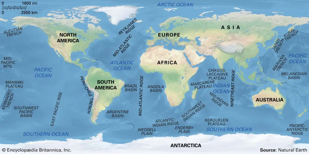
1. Distribution of Temperature in Ocean waters #
Unlike the land beneath our feet, the ocean is a dynamic entity that takes its time to react. The specific heat of water is about 2.5 times higher than that of landmass. This means water takes much longer to heat up and cool down, giving the ocean a moderating effect on our global climate.
The sun is the principal source of energy for the oceans. While the Earth’s interior does supply some heat through volcanic ridges at the bottom, it is negligible compared to the colossal power of solar insolation.
1. The Horizontal Spread: A Latitudinal Tale – If you sail from the Equator towards the frozen poles, you will feel a chill creeping in. The average temperature of the ocean’s surface water is about 27°C. However, this heat is not evenly distributed.
- The Latitudinal Rule: The temperature of surface water generally decreases from the Equator towards the poles because the amount of solar insolation decreases poleward. The rate of this decrease is roughly 0.5°C per latitude.
- The Hemisphere Divide: The oceans in the northern hemisphere record relatively higher temperatures than those in the southern hemisphere. Why? Because the northern hemisphere has a much larger extent of landmass in contact with the oceans, which heats up quickly and transfers heat to the water.
- The Highest Heat: Interestingly, the highest temperature is not recorded exactly at the Equator, but slightly towards the north of it (often referred to as the thermal Equator).
- Winds and Currents: Prevailing winds play a massive role. Winds blowing from the land towards the oceans (offshore winds) drive warm surface water away from the coast, which causes cold water from the deep to rise—a process called upwelling. Conversely, onshore winds pile up warm water near the coast, raising the local temperature. Furthermore, warm ocean currents (like the Gulf Stream) raise the temperature in cold areas, while cold currents (like the Labrador Current) bring a chill to warmer regions.
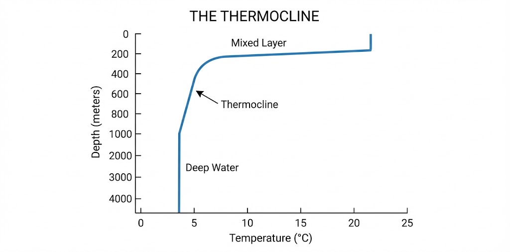
2. The Vertical Descent: Journey to the Deep – Now, let us strap on our diving gear and descend. As you go deeper, the sunlight fades, and the chill sets in. The vertical temperature structure of oceans over middle and low latitudes is divided into a three-layer system:
- The First Layer (Epipelagic): This is the top layer of warm oceanic water, about 500 meters thick, with temperatures ranging between 20° and 25°C. In the tropics, this layer is present all year round, but in mid-latitudes, it only develops during the summer.
- The Second Layer (The Thermocline): Starting around 100 to 400 meters below the surface and extending to about 1,000 meters is the boundary region known as the thermocline. Here, the temperature drops incredibly rapidly with increasing depth.
- The Third Layer (The Deep Ocean): Below the thermocline lies the cold abyss, extending to the deep ocean floor. Nearly 90% of the total volume of ocean water is found below the thermocline, living in a perpetual state approaching 0°C.
Note for polar explorers: If you were to dive in the Arctic or Antarctic circles, you would not find this three-layer system. The surface water temperatures there are already close to 0°C, so there is only one uniform layer of cold water from the surface to the bottom.
2. Distribution of Salinity in Oceans #
Our ocean is essentially a massive chemical soup. Salinity is the term used to define the total content of dissolved salts in seawater. It is calculated as the amount of salt (in grams) dissolved in 1,000 grams (1 kg) of seawater and is expressed as parts per thousand (o/oo or ppt). What makes it salty? Sodium Chloride (NaCl) is the undisputed king, making up 77.7% of the dissolved salts, followed by Magnesium Chloride (10.9%), Magnesium Sulphate (4.7%), and Calcium Sulphate (3.6%). The average salinity of normal open oceans ranges between 33 o/oo and 37 o/oo.
1. Factors Dictating the Salt – Imagine the ocean as a giant pot of soup on a stove. If you leave the heat on (evaporation), the water escapes, and the soup gets saltier. If you pour a glass of water into it (precipitation or river inflow), it gets less salty.
- Evaporation and Precipitation: These are the primary controllers of surface salinity.
- Freshwater Influx: In coastal regions, surface salinity is greatly diluted by freshwater from rivers. In polar regions, the freezing of ice increases the salinity of the surrounding water (since ice leaves salt behind), while the thawing of ice dilutes it.
- Wind and Currents: Wind can transfer water from one area to another, while ocean currents mix waters of different salinities globally.
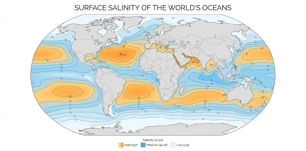
2. The Horizontal Spread: The Latitudinal Paradox – You might think the Equator, being the hottest, would be the saltiest due to evaporation. But nature loves a paradox.
- The Sub-Tropical Highs (The Saltiest Zones): The highest salinity is actually recorded between 15° and 20° latitudes. These regions coincide with high-pressure cells where the air is dry, there is hardly any rain, and subsiding winds cause massive evaporation.
- The Equator: Despite high temperatures, the equatorial region has lower salinity (around 35 o/oo) because it receives heavy, daily rainfall which dilutes the salt.
- The Enclosed Seas: Geography plays a massive role. In enclosed, hot, and dry regions where evaporation is fierce, salinity skyrockets. The land-locked Red Sea hits a massive 41 o/oo. In inland lakes, the numbers are staggering: Lake Van in Turkey (330 o/oo) and the Dead Sea (238 o/oo). Conversely, the Black Sea has very low salinity because numerous large rivers dump fresh water into it.
3. The Vertical Descent: The Halocline – Just as temperature has the thermocline, salinity has the halocline—a distinct zone where salinity increases sharply with depth.
- At high latitudes, salinity increases with depth.
- At the Equator, sub-surface salinity is lower than the surface.
- Because saltier water is denser and heavier, high-salinity seawater generally sinks below lower-salinity water, leading to a distinct stratification (layering) by salinity.
3. The Great Ocean Conveyor Belt #
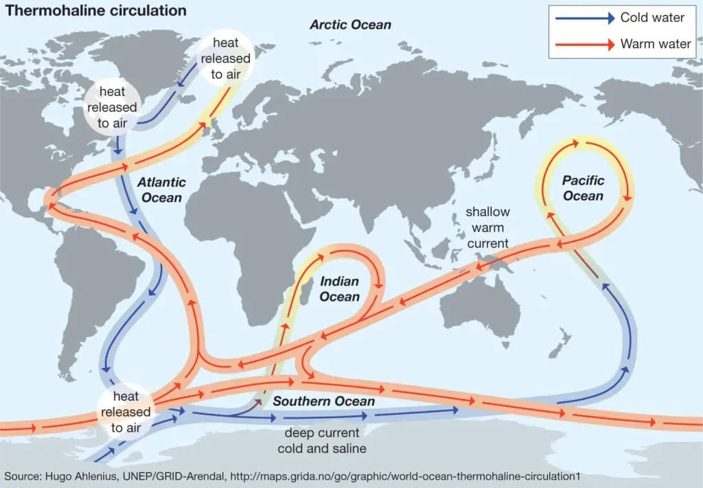
Now, let us combine the two properties. Temperature (thermo) and Salinity (haline) together determine the density of seawater. Cold water is denser than warm water, and salty water is denser than fresh water.
When extremely cold, highly saline water forms near the poles (especially in the North Atlantic), it becomes so heavy that it plunges to the deep ocean floor. This sinking action acts as a massive global pump, pulling warm surface water from the tropics poleward to replace it. This creates the Thermohaline Circulation—a slow, continuous deep-ocean current that acts as a global conveyor belt, distributing heat and regulating the Earth’s climate.
4. The Indian Context & Contemporary Challenges #
To understand the social and demographic importance of these physical properties, we need only look at India’s eastern and western coasts.
The Tale of Two Seas: Bay of Bengal vs. Arabian Sea – Why does the eastern coast of India (Odisha, Andhra Pradesh) suffer from devastating tropical cyclones so much more frequently than the western coast? The secret lies in temperature and salinity.
- The Bay of Bengal (Low Salinity): The Bay receives a massive influx of fresh river water from the mighty Ganga, Brahmaputra, and other peninsular rivers. This creates a thick layer of warm, fresh, and lightweight water floating on top of the denser, saltier water below. This high stratification (layering) inhibits vertical mixing. The warm surface water stays on top, providing an endless supply of Latent Heat of condensation—the very fuel required to spawn and sustain massive tropical cyclones.
- The Arabian Sea (High Salinity): In contrast, the Arabian Sea receives very little fresh river water and experiences high evaporation due to dry winds from the Middle East, making its surface highly saline and heavy. This heavy surface water sinks, promoting vertical mixing with the cooler waters below. This mixing cools the overall surface temperature, depriving cyclonic depressions of the heat they need to grow.
Climate Change: A Threat to the Invisible Architecture – Our modern demographic stability is deeply tied to the predictable behavior of the oceans. However, anthropogenic global warming is shifting the baseline.
- Slowing of the AMOC: The Atlantic Meridional Overturning Circulation (part of the thermohaline conveyor belt) is losing its stability. As global warming melts the Greenland ice sheets, massive amounts of fresh water are dumped into the North Atlantic. This dilutes the salinity, meaning the water no longer becomes dense enough to sink. If this pump slows down, it could drastically alter global weather patterns, potentially plunging Europe into deep freezes and disrupting the Indian Monsoon.
- Ocean Acidification & Dead Zones: As oceans absorb excess atmospheric CO2, they become more acidic. Furthermore, decreasing oxygen levels, compounded by changes in ocean circulation and agricultural runoff, are creating expanding “Dead Zones” where marine life cannot survive. This poses a catastrophic threat to global food security, particularly for coastal demographics heavily dependent on the fishing industry.
Conclusion #
The physical properties of the ocean—its temperature and its salinity—are not just abstract geographic concepts. They are the engines of the winds, the breeders of monsoons and cyclones, and the silent regulators of the air we breathe. For an aspiring civil servant, understanding these deep-water dynamics is the first step in understanding the broader challenges of climate change, disaster management, and the sustainable future of India’s coastal millions.
Mains PYQs #
- (2024) What is sea surface temperature rise? How does it affect the formation of tropical cyclones?
- (2022) What are the forces that influence ocean currents? Describe their role in the fishing industry of the world.
- (2019) How do ocean currents and water masses differ in their impacts on marine life and the coastal environment?
- (2018) What are the consequences of spreading ‘Dead Zones’ on marine ecosystem?
- (2017) Account for variations in oceanic salinity and discuss its multi-dimensional effects.
- (2015) Explain the factors responsible for the origin of ocean currents. How do they influence regional climates, fishing and navigation?
Related Latest Current Affairs #
- (November, 2025): Sentinel-6B Satellite Launch – A new ocean-monitoring satellite was launched to provide continuous, high-accuracy measurements of sea-level rise and ocean temperature patterns. This data is critical for understanding thermal expansion and climate-driven changes in global ocean dynamics.
- (November, 2025): High Sea Surface Temperatures in Bay of Bengal – The active cyclogenesis during the retreating monsoon highlighted the impact of horizontal temperature distribution. The Bay of Bengal retains very warm Sea Surface Temperatures (~28–30°C), providing immense Latent Heat that fuels frequent cyclones.
- (October, 2025): Temperature Contrasts Between Bay of Bengal and Arabian Sea – Analyses of cyclone trends explained that the semi-enclosed Bay of Bengal retains warm water (29–30°C year-round). In contrast, the Arabian Sea remains relatively cooler due to stronger winds and higher evaporation rates.
- (September, 2025): El Niño and Thermocline Dynamics – Discussions on El Niño explained how weakened Trade Winds shift warm surface waters eastward in the equatorial Pacific. This horizontal movement deepens the thermocline in the east, suppressing the vertical upwelling of cold, nutrient-rich deep ocean water.
- (September, 2025): Rising Sea Surface Temperatures Linked to Whale Strandings – The CMFRI reported a nearly tenfold increase in marine mammal strandings along India’s south-west coast. Rising sea surface temperatures (SSTs) and shifting ocean productivity patterns are significant factors disrupting marine habitats.
- (June, 2025): WMO State of the Climate in Asia Report – The WMO highlighted that rising global greenhouse gas emissions are heating the oceans, causing the thermal expansion of water. Additionally, variations in regional ocean currents are redistributing heat horizontally, driving localized sea-level rise.
- (December, 2024): Southern Ocean Carbon Anomaly and Stratification – Research showed that increased Antarctic ice melt adds freshwater to the ocean surface, making it less salty and more buoyant. This difference in salinity creates vertical stratification (a surface “lid”) that prevents deep, carbon-rich waters from mixing with the surface.
Sources: #
- NCERTs (6th to 12th Class)
- Standard reference books (GC Leong, Majid Hussain)
- Encyclopedia Sites: Wikipedia, Britannica
- News and Current Affairs Platforms (The Hindu, Indian Express, The Nature, CSE Down to Earth)
- Research and Design Supported by Google Gemini, OpenAI ChatGPT, Other AI tools